Pensé hacer esta ruta durante el verano, pero no encontré el momento. La ventaja de hacerla ahora en otoño es que no hace tanto calor, y por lo tanto podía llevar a Monty, pero el inconveniente es que hay menos horas de luz. Quería subir a la cumbre que me faltaba por conocer de la Sierra de Peña Sagra - El Canto de la Traspeñuela. De paso cogí un par de senderos que no conocía - el primero, la subida por la pista que sale de Somaniezo en el Valle Estrechu hasta la Ermita de la Luz. Puede que ya lo hice hace años pero no me acuerdo ahora. Saliendo del pueblo hace el este, la sierra se ve claramente.
I've visited the Sierra de Peña Sagra several times, but had never been to part of the ridge immediately to the west of the highest point. Monty and I set off from Somaniezo in Liébana and followed the track that leads up to a little chapel - the Ermita de la Luz. The mountain is clearly visible as you make your way out of the village.

La pista es un poco aburrida y muy pindia, aunque detrás quedan vistas bonitas
The track is a extremely steep, and I stopped several times to take in the views behind me.


El plan era buscar un sendero desde la Ermita hacia arriba, y explorar las zonas que no conocía. Condicionaba un poco mis andanzas la presencia de un grupo de cazadores en el monte entre Invernailles y Somaniezo, así que tomé la pista (GR) que va hacia Luriezo (noroeste). A mi izquierda quedaba un bonito bosque.
My idea was to try to find a path up from the chapel. I also had to steer clear of a hunting party looking for wild boar in the woods to the right of the track. So, I took the track that heads NW from the Ermita de la Luz.

Tardé por lo menos media hora desde la Ermita en llegar al Dornaco, donde hay una choza, y la pista bifurca. A la izquierda desciende a Luriezo, así que cogí el ramal que sube a la derecha - el segundo de los senderos que desconocía.
I took at least half an hour from the Ermita to a spot where there's a hut and a fork in the track. The one on the left goes down to Luriezo, but we took the one to the right.

Siguiendo las indicaciones de mi mapa, dejé la pista que sigue hacia el oeste y cogí un camino herboso a la derecha que acaba bastante pronto. A partir de ahí seguimos hacia arriba a la izquierda, flanqueados por las rocas.
Shortly afterwards we left that track in turn to take a grassy path to the right that soon peters out. Thereafter we carried on up towards the left with cliffs on either side.

Llegamos a otra choza, viendo la cresta justo por encima de nosotros. Los senderos no son nada claros a partir de aquí, y subimos en diagonal hacia la izquierda..
We reached another hut, with the top of the ridge above us. Paths are not clear from here, and we carried on up diagonally to the left.

La cumbre del Tumbo se veía con una claridad que echamos en falta cuando la subimos hace un par de años y estaba envuelta en una nube.
Last time I was up here we climbred El Tumbo, but couldn't see anything for the cloud - today it stood out clearly.

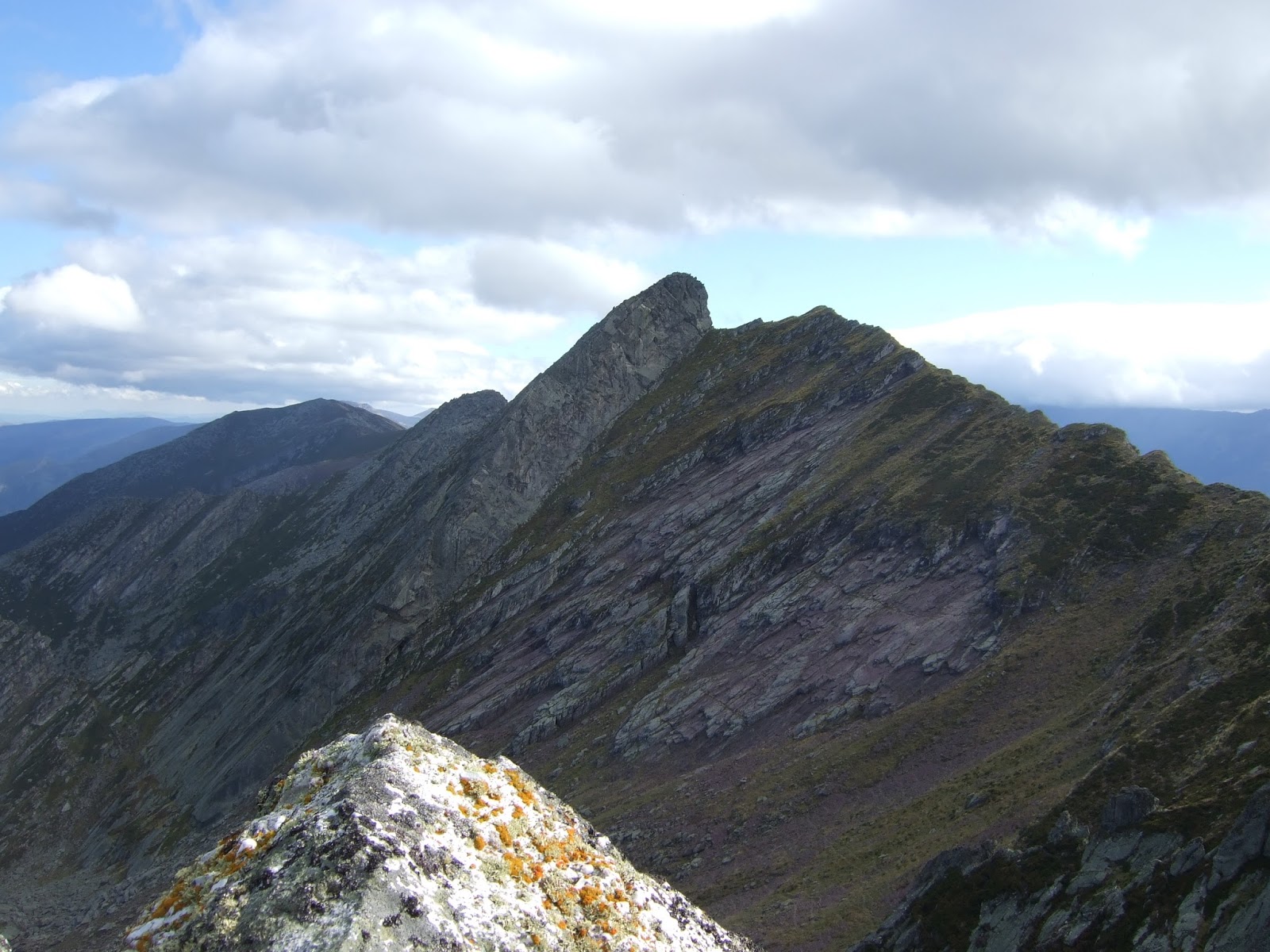
Nos asomamos a la arista a mitad de camino entre el Tumbo, y Pico Paraes a la derecha
We came out onto the ridge between el Tumbo and Pico Paraes, to the right.

Mirando hacia el norte y el mar.
Looking towards the north and the sea.

Mirando hacia atrás, por el lado por donde hemos subido, estamos más o menos encima del Dornaco y bastante más abajo todavía queda Somaniezo
Looking back down the side we came up, we were right above Dornaco, which in turn is above Somaniezo, quite a way further down.

Sabía de otra excursión a Paraes que hay un sendero más o menos claro que va por debajo de la cresta en el lado sur, así que la seguí hasta rodear el pico.
I followed a path that skirts round below Paraes.

La última parte a campo a través
Eventually the path dies out but we made our way up the last part without any difficulty

Salimos a la cresta y hacia la derecha queda la parte que pretendía recorrer. En primer término hay un cueto, donde paramos a comer. Llevábamos ya 4 horas andando.
Back out onto the ridge; I now intended to discover what lay to the right. We first walked up to the hill to stop for a bite to eat. We'd already been walking for 4 hours.

Desde ese punto, abajo se ve la pista que sube desde la Ermita hacia Invernailles (izq) y baja a Somaniezo (der)
From the hilltop I could see the track we'd come up from Somaniezo down to the right, while to the left is the one that heads east from the Ermita.

El Cuernón al fondo
Further along lies the highest point of the Sierra - the Cuernón

Hacia el otro lado Pico Paraes con Los Picos de Europa detrás. Este es de los pocos lugar en alto a que Monty puede llegar, debido a la presencia de muchos bloques de conglomerado.
To the other side, Pico Paraes, with the Picos de Europa providing the backdrop. This is one of the few points of elevation that Monty can get to in these mountains, owing to the large rocks that often hinder his progress.


Bajamos hacia el este, viendo la sierra de Peña Labra en frente, a punto de desaparecer completamente debajo de la nube.
We descended going eastwards, with Peña Labra across the way, about to be completely enveloped by cloud.

Bordeamos unas rocas grandes y trepamos por los bloques hasta el punto más alto que se dirige hacia el norte - El Canto de la Traspeñuela. Desde allí se ve cueto recién ascendido y Pico Paraes detrás.
We went round a large outcrop and clambered over the boulders to the highest part of the spur that heads northwards away from the main ridge. From here I looked back on the hill we'd just been to and Pico Paraes behind.

Hacia el otro lado, el Cuernón de Peña Sagra
To the other side, el Cuernón de Peña Sagra
Y entre el Cuernón y donde estamos se ve esta mancha tan bonita de azul, que según mi mapa se llama el Pozón. No lo había visto antes, debido a la presencia de nubes en el lado norte las dos veces que he subido al Cuernón. Hoy las cosas eran distintas porque soplaba el sur, y bastante fuerte por cierto.
And then I espied the blue lagoon below, called el Pozón on my map. which I'd never seen before due to the habitual cloud to the north on previous visits to the Cuernón.

Las rocas continúan en línea descendiente hacia el norte
From this point the rocks fall away northwards.

Por la hora decido que toca bajar así que atravesamos el terreno caótico hacia la cresta
It was time to be heading back, so we crossed the rock-strewn ground directly to the edge of the ridge.

Una mirada atrás al Canto, que da una idea del paisaje característico de las cumbres de Peña Sagra
A look back at the Canto de la Traspeñuela, which gives some idea of the characteristic landscape near the summits on Peña Sagra

No me apetecía volver por el mismo camino hacia el Dornaco, y bajar a Luriezo para luego andar hasta Somaniezo, así que decidí bajar directamente por la ladera a la pista a la altura de la Ermita de la Luz (en un claro a la izquierda de esta foto.) Esperaba que la maleza no nos causara demasiados problemas...
Rather than going back the way we'd come, I decided to go straight down the mountainside to the track. Hopefully the vegetation wouldn't be too much of a problem...

Mientras tanto las nubes avanzaban
Meanwhile the clouds were on the move

La primera mitad de la bajada muy bien - bastante empinada, pero andando con cuidado sin ningún problema. La segunda mitad se vislumbraba menos placentera...
The first half of the way down was fine - pretty steep, but no issues as long as you tread carefully. The second half looked less straightforward...

Tenía que evitar el escajo (aulaga) dentro de lo posible, pensando en Monty, y pensé que una vez pasada la zona de escoba, los helechos serían más cómodos, pero ni mijita - la última parte era muy desagradable con zarzas y demás obstáculos, y una vez alcanzamos la pista quedamos los dos un rato sentados para recuperarnos del esfuerzo. En total tardamos 75 minutos en bajar hasta la pista justo al lado de una curva hacia la derecha que te lleva a la Ermita en seguida. De hacer esta marcha otra vez habría cogido una de las sendas de ganado que cruzan la ladera a la mitad de la bajada hacia la izquierda para ver la posibilidad de seguir el curso del arroyo por su lado izquierdo. Cuando había bajado demasiado para poder cruzar hasta el otro lado del barranco, veía lo que parecía una senda enfrente. De hecho, en la curva que acabo de mencionar hay el comienzo de un sendero, pero no sé si luego se hace impracticable. Leí que había un camino en esta zona, pero no aparece en los mapas que he consultado.
I had to avoid the gorse bushes as far as possible, with Monty in mind, and I reckoned that once we were past the broom, the predominantly fern-covered area would be easier going, but it was not to be, with brambles and other obstacles. It took us an hour and a quarter to get down to the track and we came out by the bend to the right just before the Ermita. In retrospect, I should have taken one of the cattle paths that cross the hillside about half-way down and looked for a path following the stream down to the bottom. It noticed one further down, but by then it was too late to cross over to the other side of the gully. There is supposed to be a path, but it's not on any map I've seen.
Total, que luego bajamos por la misma pista pindia hasta el pueblo. Desde aquí la ladera por donde habíamos bajado no parece entrañar la complicación que realmente tenía.
Anyway, we then went back down to the village via the same track we'd come up. Looking back at the mountainside we came down, it doesn't look nearly as tricky as it turned out to be.


No hay comentarios:
Publicar un comentario
Please feel free to leave a comment!
¡Agradezco tus comentarios!